As snow melts in the High Sierra, rivers downstream swell and can impact access to Yosemite National Park, leaving us with one looming question, “Will Yosemite Flood?”
Over the winter of 2022-2023, a series of atmospheric rivers resulted in one of the snowiest winters on record in the Sierra Nevada. Snow surveys recorded hundreds of inches of snowfall. This snow is vital to the health of ecosystems both in the mountain range as well as the Central Valley and its agriculture.
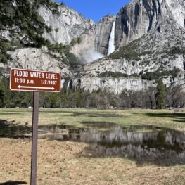
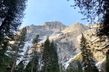
Yosemite Falls is thundering beautifully this spring. Memories of past floods are seen in signs across the Valley.
As the snow melts it flows through creeks and rivers. But when large amounts of Yosemite snow melt — particularly when weather is warm and snow is melting quickly — flooding can occur. And with modern computer programs, scientists can model when and where to expect flood conditions. It can be helpful to know where the data is coming from that informs these hydrologic forecasts.
So, today we’ll cover:
- Hydrologic forecasts: what are they and where are
- Trip planning tips during flood-watches
- Which waterfalls are the happiest during high water years
- And other Yosemite flooding 2023 trip planning tips.
Hydrology of Yosemite
Every water year is different in Yosemite. Yosemite floods or experiences higher water flows every spring as the Yosemite snow melts. Two data sources that help us understand Yosemite’s hydrology are streamgauges and snow surveys.
Streamgauges tell us the amount of the water in a river or stream at a certain location. There are two streamgauges on the Merced River in Yosemite Valley which are maintained by the United States Geologic Survey (USGS): Happy Isles Bridge in the east and Pohono Bridge in the west. Data from these gauges can be viewed in real time online.
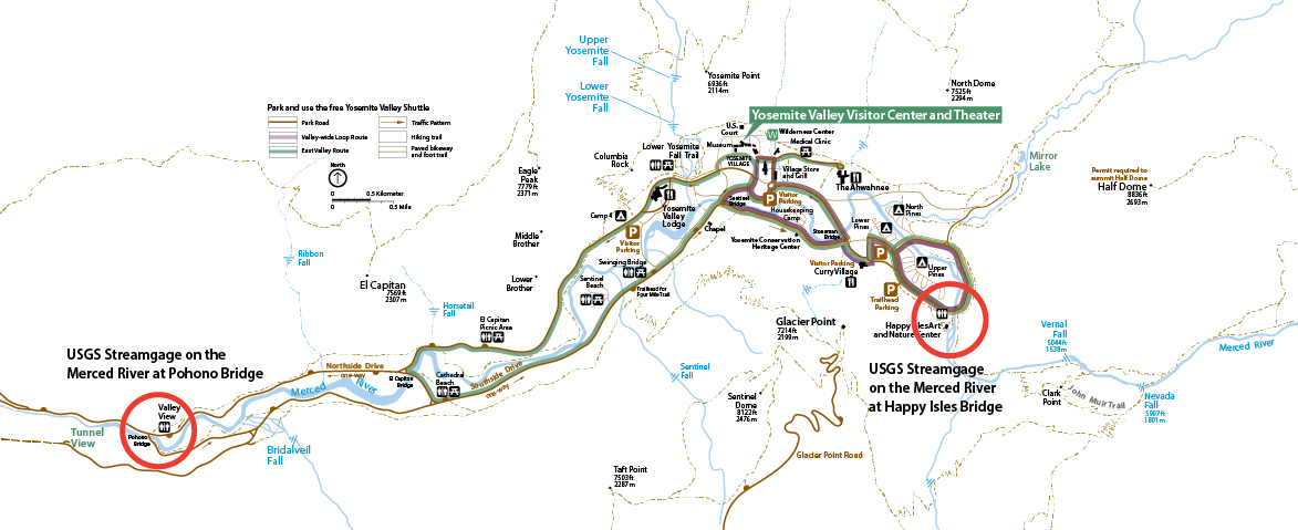
Yosemite Valley with the location of USGS streamgauges at Pohono and Happy Isles bridges circled respectively.
Often times Yosemite National Park will cite the water level at the Pohono Bridge when they reference water safety regulations for boating and other water activities.
Another data source for hydrologic forecasts are snow surveys. Many snow surveys are still done in person throughout the Sierra. Intrepid skiers access remote locations carrying long tubes in order to make measurements of the snowpack as shown in the Yosemite Nature Note video on Snow. That data is then reported to the California Department of Water Resources.
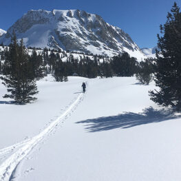
Skiing home from the Fletcher 2 snow survey on March 26, 2023. Photo courtesy of NPS.
According to the California Department of Water Resources, the winter of 2023 has one of the largest snowpacks on record — in many places the snowpack is more than 200% of the average. The final snow surveys data for Yosemite National Park shows the Merced drainage is 231% of average (and 189% of April 1 averages) and the Tuolumne drainage is 253% of average (and 207% of April 1 averages).
Using computer modeling, knowing the amount of snow is in the Sierra, combined with ongoing meteorological or weather forecasts, hydrologic forecasts are created to help the park plan ahead.
Finding ways to be flexible in flood-prone years.
As we transition from a winter with record-breaking snowfall to spring and summer, there may be times when Yosemite National Park may close certain areas of the park when flood levels are predicted. This could be when temperatures warm suddenly causing more snow to melt rapidly or if rain falls at higher elevations. When flood warnings or closures occur, look for updates directly from Yosemite National Park on their Yosemite Conditions page.
Remember Yosemite National Park is a large geographic space — 1,200 square miles! It is rare that the entire park will close. When a closure occurs, know that park staff are working to reopen the park as soon as it is safe to do so. When one area closes it could also be seen as a golden opportunity to explore a different corner of the park or try a new trail. Giant sequoia groves or Hetch Hetchy could be excellent alternatives for visitors looking for scenic day hikes away from Yosemite flooding or Yosemite flood prone areas. Rangers in the park will have the best recommendations for you.
Wonderfully Wet Waterfalls
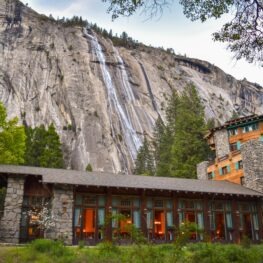
The Royal Arches Cascade seen flowing behind the Ahwahnee Hotel. Photo by John Ruddock.
Some people may call Yosemite’s waterfalls temperamental, especially on dry years. In reality many of the most famous waterfalls are ephemeral — meaning they only last while there is snow up above. Yosemite Falls, which can be viewed through a Conservancy webcam, is notorious for going dry in late summer. Alternatively, when there is a lot of snow above, there are a lot of waterfalls below.
Some waterfalls that are best viewed — from a distance — during big water years include:
- Staircase Falls by Curry Village: best viewed from Stoneman Meadow.
- Horsetail Fall off of the eastern side of El Capitan: best viewed from the path along El Capitan Meadow.
- Royal Arches Cascades flowing over Royal Arches: best viewed from the path around Ahwahnee Meadow.
- Ribbon Falls on the western side of El Capitan: best viewed from the path along El Capitan Meadow.
- Sentinel Falls: best viewed on the western side of Sentinel Rock.
Other waterfalls are very impressive, especially because you can hike trails near them. These include:
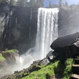
Vernal Falls misting up the Mist Trail. Photo by Michael White.
- Yosemite Falls: Even standing on the bridge of the Lower Yosemite Fall Trail can leave you feeling windswept! Upper Yosemite Fall is a strenuous 7.2-mile hike with 2,700 feet of elevation gain. Lower Yosemite Fall is an easy 1-mile loop, with an accessible option to the viewing platform.
- Vernal Falls: You’ll quickly learn why the Mist Trail got it’s name when hiking past Vernal Falls. Highly recommend wearing raincoats and waterproof shoes! From the trailhead to Vernal Falls is a 2.4-mile round trip with 1,000 feet of elevation gain, making this hike short and strenuous. Please be extra careful on the stone steps when they are wet and slippery.
- Nevada Falls: Continuing past Vernal Falls to Nevada Falls creates a 5.4-mile round trip with 2,000 feet of elevation gain.
- Chilnualna Falls in Wawona: A strenuous 9.2-mile round trip with 2,400 feet of elevation gain leads to a roaring series of cascades on wet years.
- Wapama Falls at Hetch Hetchy: A moderate, 5-mile out-and-back hike with 500 feet of elevation gain at the reservoir. It is not recommended to cross the bridge at Wapama Falls when water is flowing over the bridge.
Header photo: Dana Fork of the Tuolumne Bridge on April 13, 2023. Photo courtesy of NPS.