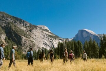
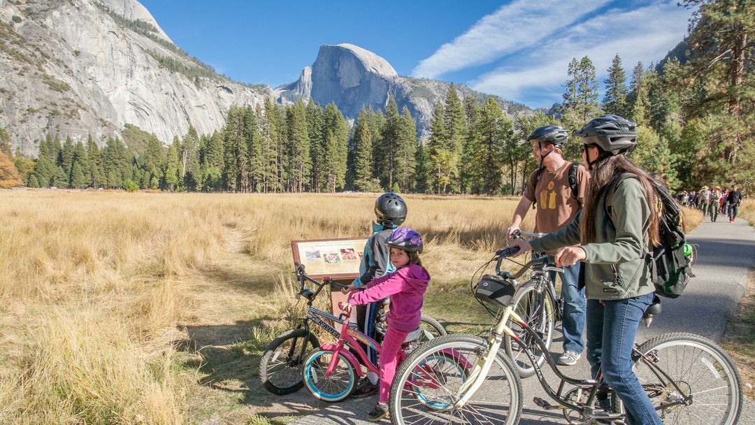
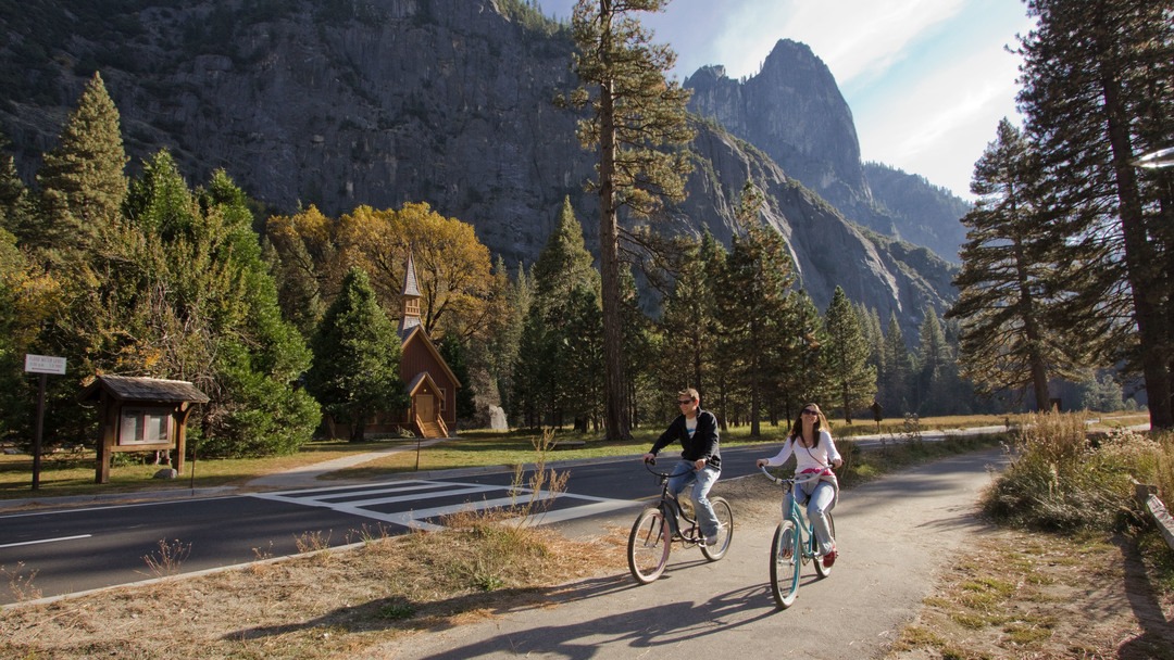
Yosemite is well-known for its epic hikes and viewpoints, but have you ever thought of opting to explore the park via bike? Yosemite Valley hosts 12+ miles of paved bike/pedestrian paths that offer visitors a unique type of adventure. From short rides for waterfall viewing to full loops of the Valley floor, scroll down to find our favorite Yosemite bike rides!
Need a bike? Yosemite Conservancy’s free Bike Share opens for the season in late spring, and allows visitors to borrow bikes for short trips (up to two hours). During the summer season, Travel Yosemite also offers half- and full-day bike rentals from Curry Village and Yosemite Valley Lodge.
Biking allows you to explore the park’s beauty in an immersive way and saves you time and stress by not having to drive and park at each new location you visit. Please observe the 15mph speed limit, obey all stop signs, stay off unpaved trails, and remember that children under 18 years of age are required by law to wear helmets (and adults are encouraged to wear them as well).
If you are a skilled cyclist, you can also ride on regular roads in the park if you follow all the rules of the road and bike with the flow of traffic. Be aware that drivers are often distracted by the beauty of the park.
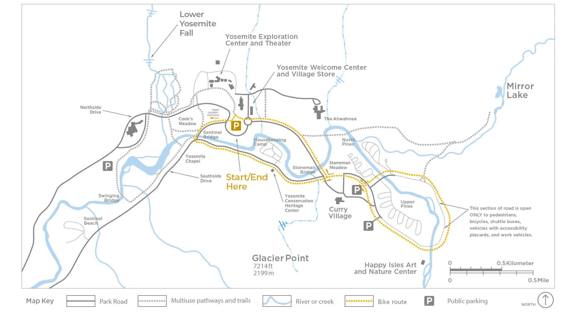
1. Yosemite Falls Viewpoints Route
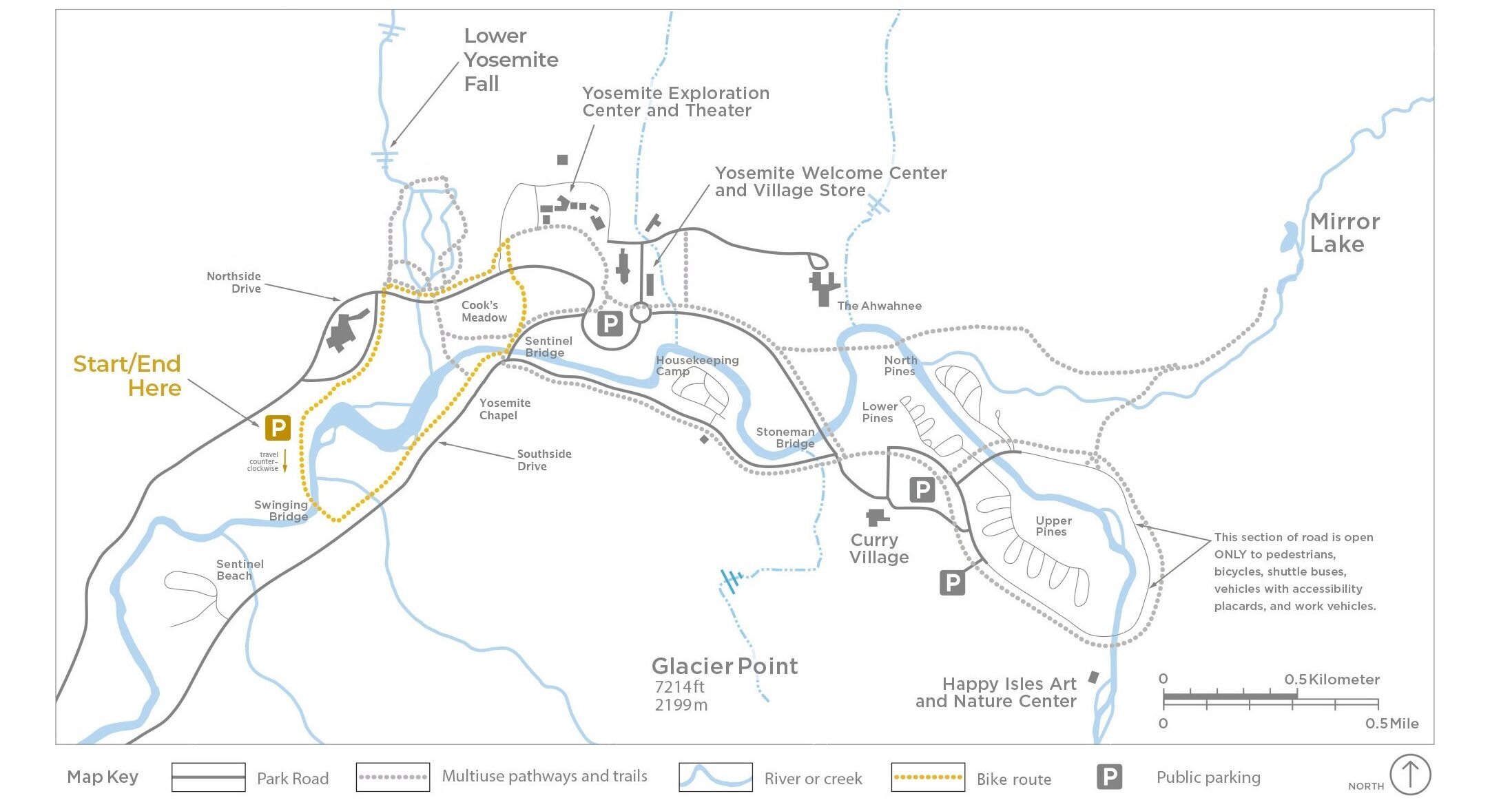
Mileage: 1.5 miles | Minutes: 15 – 20 | Elevation gain: Mostly flat | Starting point: Yosemite Village Parking Area
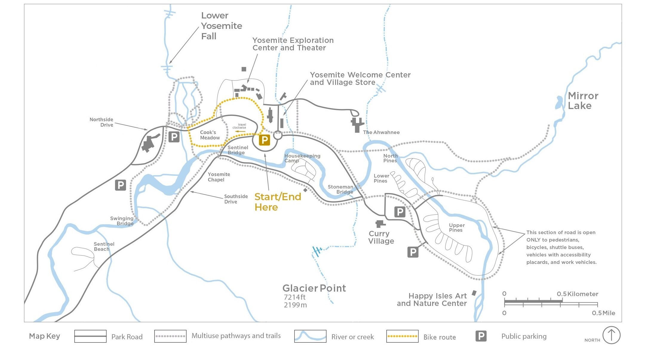
This little loop is perfect for those looking for a quick ride that’s fit for beginners too. Starting from the Yosemite Village Parking area (this might be the most difficult part of the journey!), you’ll make your way south-west (away from the Welcome Center and bathrooms toward the far side of the parking area). You’ll want to look for the crosswalk at the intersection where Northside Drive and Sentinel Drive intersect.
Stay on the paved shared pedestrian and bike path along the side of Cook’s Meadow. You’ll approach a small parking lot along Sentinel Drive where the bike path will dip down toward a lovely view of Yosemite Falls.
Yosemite Falls is one of the world’s tallest at a height of 2,425 feet. As you take in its grandeur, see if you can spot the three waterfalls that make up Yosemite Falls: Upper Yosemite Fall, the middle cascades, and Lower Yosemite Fall.
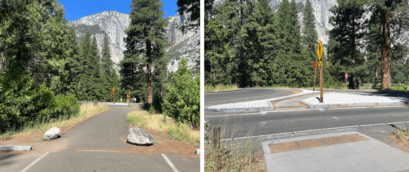
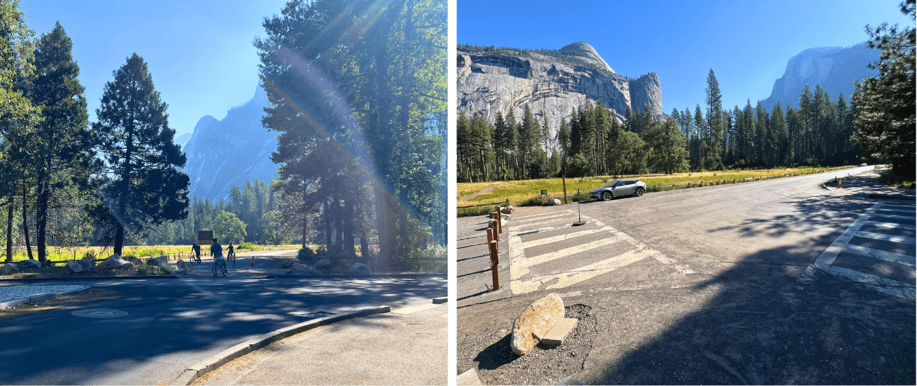
Route Clarifications. To start riding, you’ll first have exit the parking lot. Locate the paved path in the north-west corner of the lot (pictured right). As you exit, watch out for cars as you follow the path across Northside Dr (pictured left).
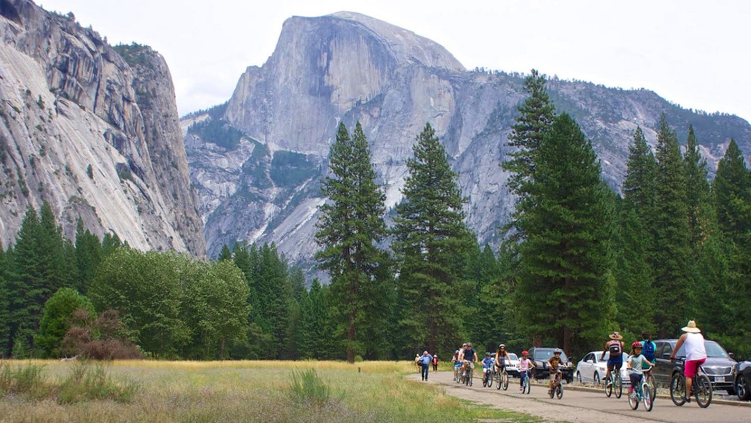
After soaking in views of the falls, this route will take you around Cook’s Meadow — along the way, look out for stunning views of Half Dome and Sentinel Rock. On the far side of the meadow, you will cross Northside Drive near shuttle stop 6. From here turn right following signs for the bike path through Yosemite Village.
In Yosemite Village the bike path will lead you past various buildings: The Yosemite Museum, Exploration Center and Theater, Ansel Adams Gallery, the Wilderness Center, the post office Degnan’s Café and finally the Yosemite Village Store and Yosemite Valley Welcome Center. The loop eventually will bring you back to your starting point, the Yosemite Village Parking Area.
Be sure to pop inside the new Yosemite Valley Welcome Center! If you find yourself wanting to bike a little farther, check out some of the other rides starting from Yosemite Village down below.
Points of Interest: Views of Yosemite Falls; Cook’s Meadow; Yosemite Museum; Yosemite Exploration Center; Yosemite Village; Yosemite Valley Welcome Center.
Cook’s Meadow with views of Half Dome and Yosemite Falls (out of frame). Photo by Yosemite Conservancy/Keith Walklet.
2. Mini Meadows Loop
Mileage: 2.5 | Minutes: 15 – 25 | Elevation gain: Mostly flat | Starting point: Yosemite Falls Parking
Enjoy the scenic beauty of Yosemite’s meadows on this ride family-friendly ride!
Your journey will begin from the Yosemite Falls Parking Lot (near Camp 4), from where you’ll head south on the Valley bike path — again, this will be the most difficult part of the journey. In the parking lot you’ll head away from Camp 4 looking for a paved path toward Leidig Meadow and Swinging Bridge.
Pause on Swinging Bridge to see a beautiful view of Yosemite Falls over the Merced River. In Yosemite, the Merced River is a popular spot for rafting during the summer when the flow is high. Though it’s unlikely you’ve managed to pack a floatie on your bike (and we’re not sure how you’d get back to your bike), you can always just take a quick dip at the beach at Swinging Bridge before continuing your ride.
When you’re ready to continue on the bike path you’ll pass by more scenic meadows toward the Yosemite Chapel on the other side of Southside Drive — a structure built in 1879 that is still an active site of worship and wedding ceremonies throughout the year.
Route Clarifications. When you first enter the Valley Lodge Day Parking Area (pictured left), you’ll notice a red fire hydrant in the distance on the left side of the road. This is marks the entrance to the bike path. Be sure to take the paved path that veers to the left of the hydrant and into the woods (pictured right).
Continue past the chapel and turn left onto Sentinel Bridge. Be sure to look to your right to see a spectacular view of Half Dome with the Merced River from the bridge. As you come down from the bridge you can pause and take in the view of Yosemite Falls at Cook’s Meadow before heading on the path to the left across the meadow.
On the other side of the meadow, you’ll cross Northside Drive and then turn left, staying on the shared pathways past the Lower Yosemite Fall Trailhead. There’s plenty of bike racks along this portion of the bike path so feel free to park and enjoy the 1-mile loop hike.
Just past the Lower Yosemite Fall Trail area you’ll cross Northside Drive again heading toward the Yosemite Valley Lodge. Here the path can be tricky to follow. You’ll take the crosswalk heading into the parking area. Look for a paved sidewalk/shared path on the left and look for the path to dip down behind the hotel buildings. Here you’ll be on a quiet forested path near the river and not trying to bike through a busy parking lot.
Shortly you’ll find yourself back at the Yosemite Falls Parking Lot. If you’re feeling adventurous you can always park your bike and take on the Upper Yosemite Falls Trail from behind Camp Four.
Points of Interest: Cook’s Meadow; Leidig Meadow, Sentinel Bridge; Merced River; Swinging Bridge; Views of Half Dome and Yosemite Falls; Yosemite Chapel.
Biking past Yosemite Chapel on Southside Drive. Photo by Yosemite Conservancy/Keith Walklet.
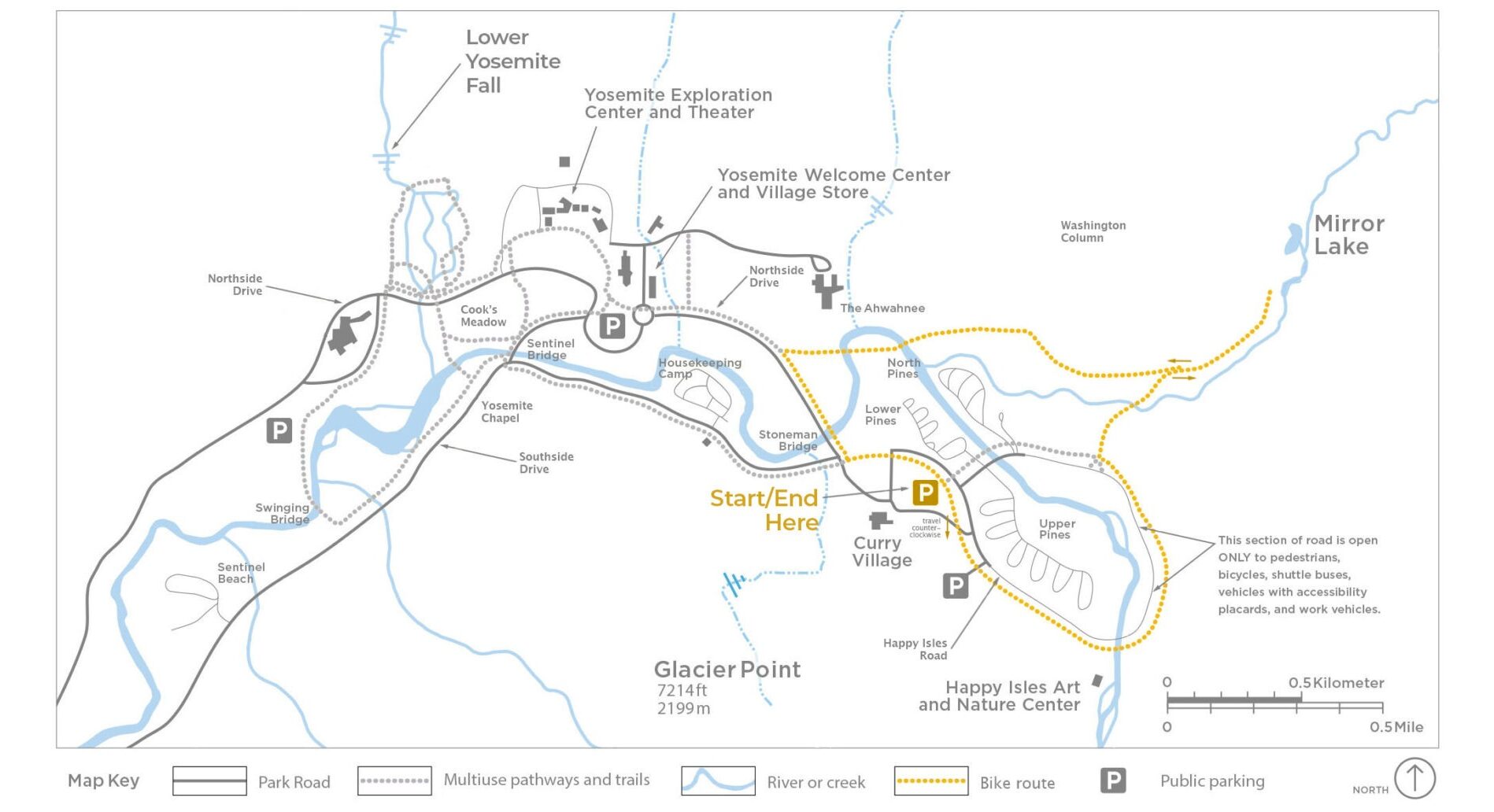
3. Happy Isles and Curry Village Loops
Mileage: 4.5 | Minutes: 25 – 40 | Elevation gain: Mostly flat | Starting point: Yosemite Village Parking Area
Explore the east end of Yosemite Valley on this ride by Curry Village and Happy Isles. Starting from the Yosemite Village parking lot, make your way south-west (away from the Welcome Center and bathrooms toward the far side of the parking area), and look for the crosswalk at the intersection of Northside Drive and Sentinel Drive.
Stay on the paved shared pedestrian and bike path along the side of Cook’s Meadow until you reach a small parking lot along Sentinel Drive. From here, take the path furthest left to bike over Sentinel Bridge. Then cross Southside Drive and then turn left to head east on the bike path that parallels Southside Drive.
Follow this path past Housekeeping Camp and the Yosemite Conservation Heritage Center (stop here during the summer months to learn about Sierra Club history in Yosemite).
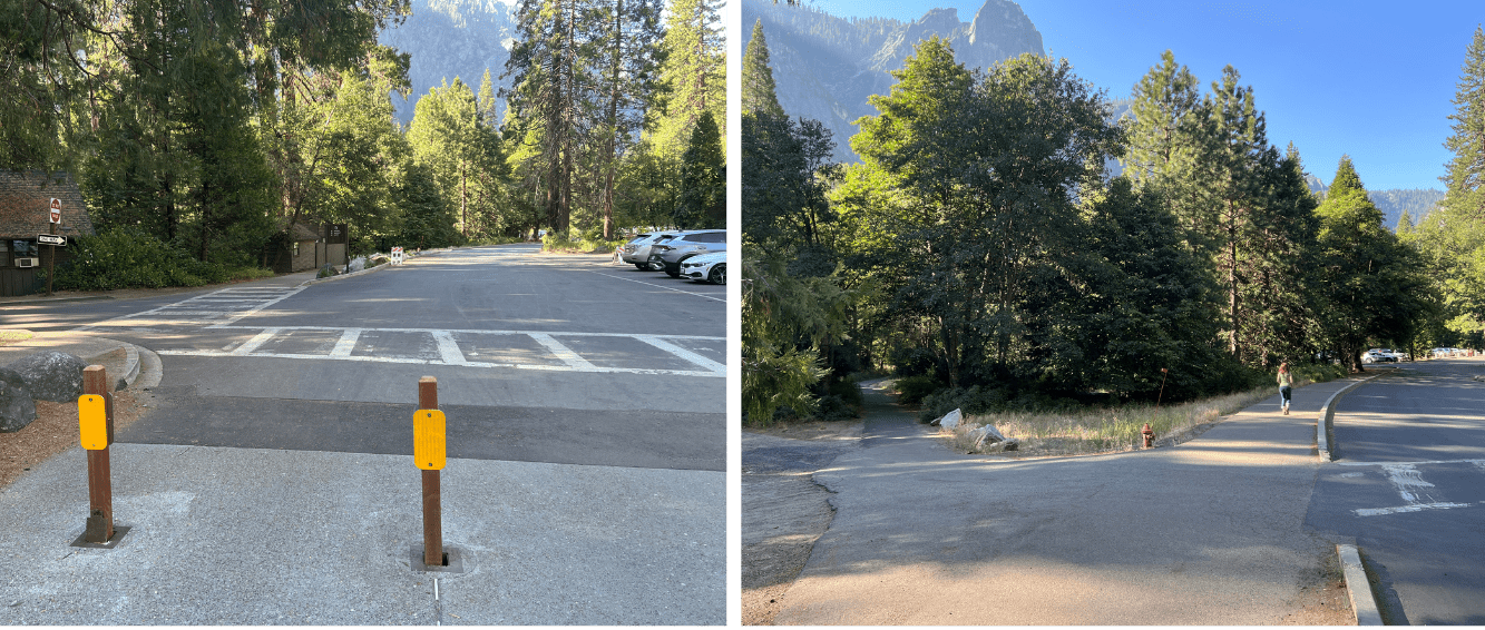
Route Clarifications. There are two points on route 2 where you might do a double take. The first (pictured left) is at the intersection of Southside and Northside Drive, where you’ll continue straight onto the path between the trees. The second (pictured right) is shortly after when the no bike section ends. Here, you’ll need to merge onto the bike path on the right side of the road.
You will come to the intersection of Southside and Northside Drive. Cross here to continue straight, following the bike pedestrian path through Stoneman Meadow. On the other side of the pedestrian zone, you can either turn right to pop into Curry Village or continue straight (look for the shared bike/pedestrian path on the right side of the road).
By continuing straight you’ll pop out onto the Happy Isles Loop Road. For a short distance you will be sharing the roadway with cars. Please be aware of traffic. Continue past the Road Closed/Authorized Vehicles Only sign onto the Happy Isles Loop where you will be sharing the road with shuttle buses, work vehicles, and vehicles with accessibility placards.
Along the Happy Isles Loop you could stop at the Happy Isles Art and Nature Center, home of the Conservancy’s Art Program. You’ll also pass trailheads for the Mist Trail/Vernal and Nevada Falls/as well as Mirror Lake.
When exiting the Happy Isles Loop Road be sure to transition back to the shared bike/pedestrian path. You’ll pass campgrounds, cross the street before turning right and retracing your route to the Southside/Northside junction. This time you’ll turn right and follow the path along Northside Drive passing Ahwahnee Meadow.
The last step on this journey is navigating the roundabout and reentering the Yosemite Village parking lot on the opposite side that you originally left from.
Points of interest: Merced River; Views of Half Dome; Happy Isles Bridge; Happy Isles Art and Nature Center; Mist Trail; Mirror Lake trail.
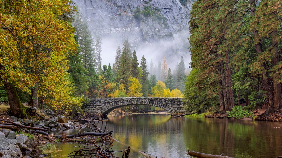
An autumn view of Stoneman Bridge and the Merced River. Photo by Michael Stone.
4. Curry Village to Mirror Lake Route
Mileage: 4.5 | Minutes: 25 – 45 | Elevation gain: 170 feet | Starting point: Curry Village Parking Lot
Skip the hike to Mirror Lake by biking there! This longer ride with a bit more elevation gain is a unique way to get around the back corner of the Valley.
Starting from the Curry Village parking lot, you’ll want to head east towards the bike path around Happy Isles Loop Road. A little way down the path you’ll find views of the Merced River at the Happy Isles Bridge before going over a moderate hill.
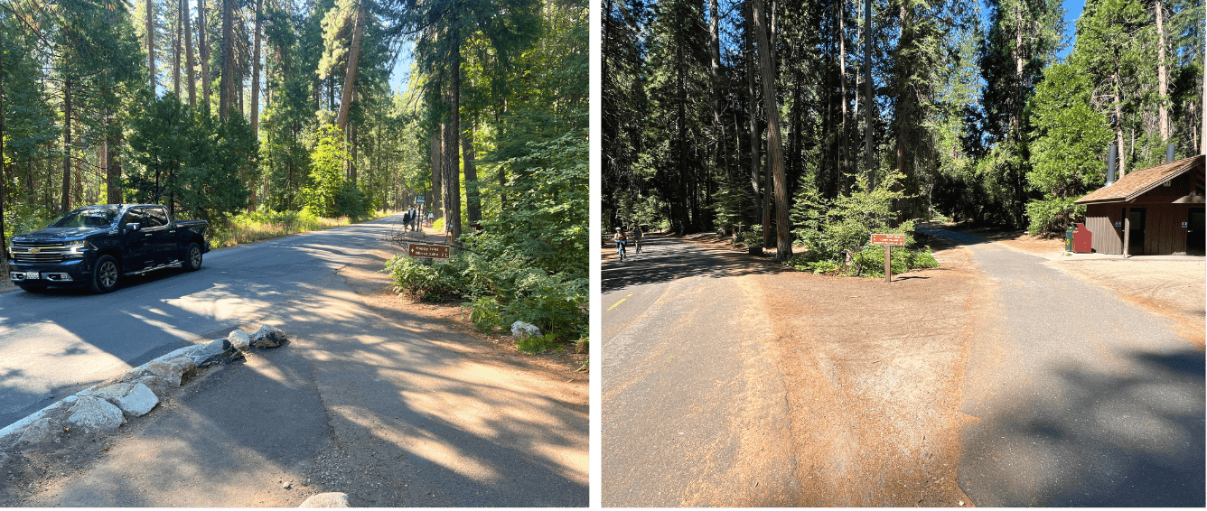
Route Clarifications. Happy Isles Loop (pictured left): After passing Curry Village, you will need to merge onto Happy Isles Rd — watch out for cars as you share the road at this point. Mirror Lake Return (pictured right): On your return from the lake, be sure to stay right on the path in the direction of Yosemite Village.
When you reach Mirror Lake shuttle stop, veer right and follow the road until it dead ends. This is the perfect place to lock up your bike and take a mid-ride hike! The five-mile loop around the lake traverses directly under the base of Half Dome and offers unique views of Tenaya Canyon, Mount Watkins, and Washington Column.
Mirror Lake is a seasonal lake, at its fullest in spring and early summer thanks to fresh snowmelt, and more of a sandy meadow in the summer and fall.
Now it’s time to make your way back. Retrace your steps (or wheel spins) until you reach a junction near the bathroom. Take the path heading off to the right all the way back to Northside Drive. Keep an eye out for more stunning views of Washington Column on the right.
When you reach Northside Drive, turn left onto the bike pedestrian path and you’ll soon find yourself back in Curry Village, where you’ll find some of our favorite pizza in the Valley at the Pizza Deck.
Points of interest: Merced River; Quiet corners of the Valley; Unique views of Half Dome from its base; Mid-ride hike at Mirror Lake.
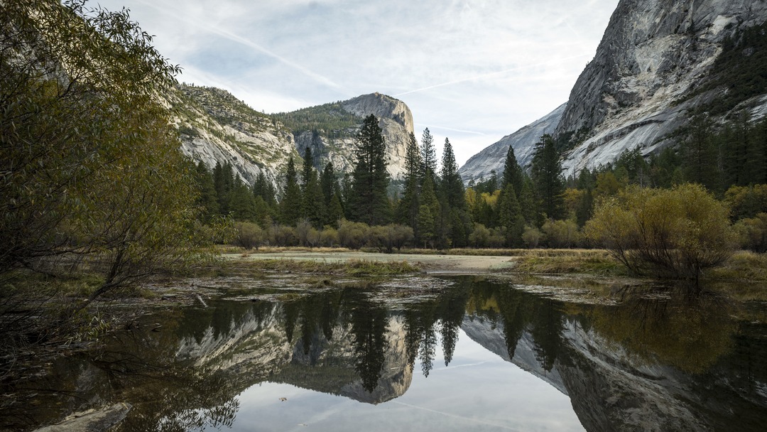
Mirror lake in autumn with Mount Watkins in the background. Photo by Christopher Michel.
5. Yosemite Valley Loop
Mileage: 7.5 miles | Minutes: 45 – 60 | Elevation gain: 130 feet | Starting point: Yosemite Village Parking Area
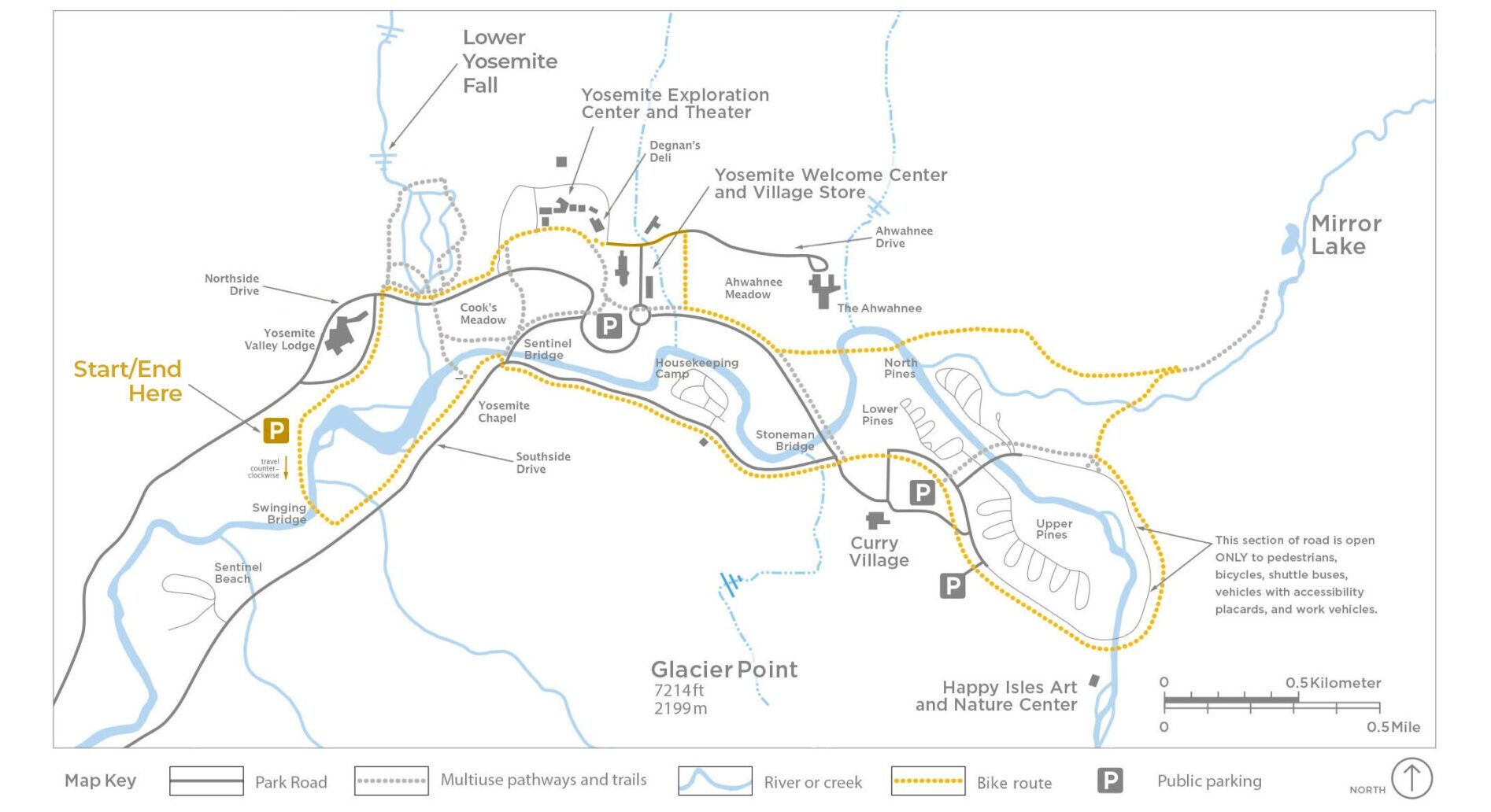
What happens when you put a handful of our favorite bike rides together? You get the full Valley experience! From stunning views of Half Dome to Yosemite Falls, this final favorite has something for everyone.
Starting at the Yosemite Falls Parking Lot (see Mini Meadow Loop for extra details) you’ll head toward Swinging Bridge across Yosemite Valley. This first section of the loop will have stunning views of Yosemite Falls with the Merced River and Yosemite meadows. After crossing Swinging Bridge, follow the path as it turns left along Southside Drive and continue until you reach the Sentinel Bridge junction.
Here you’ll cross the road to follow the path toward Curry Village and onward along Happy Isle Loop Road and onto the Mirror Lake trail (see Curry Village to Mirror Lake route for a possible hike add-on). The shared bike pedestrian path from the Mirror Lake trail to Northside Drive will take you over historic bridges — the Sugar Pine and Ahwahnee Bridges — before dropping you out along Northside Drive.
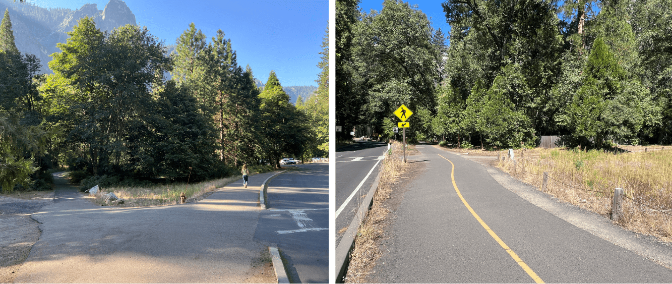
Route Clarifications. For details on starting your route from the Yosemite Falls Parking Area (pictured left), check the “route clarifications” photo caption under route 2. Later in the ride you will make a turn right after Ahwahnee Meadow (pictured right) directly after the crossing sign.
Bike along Ahwahnee Meadow with beautiful views of Yosemite Falls and Royal Arches. On cliffs to the left of Yosemite Falls, you might also see the faint outline of Yosemite’s oldest historic trails — Yosemite Falls Trail, built in the 1870s — where hikers make the arduous climb to the top of Upper Yosemite Fall.
After a couple hundred feet, you’ll turn right to stay on a path along a row of employee homes at the far edge of Ahwahnee Meadow. This path will take you to Ahwahnee Drive. Here you can either turn right travel about a half a mile to visit the Ahwahnee — a historic luxury hotel designed to highlight its natural surroundings, that has been visited by royalty and presidents — or turn left to continue on your Valley loop.
Turning left, you’ll enter Yosemite Village near Degnan’s Deli – a great stop for a snack! You can also turn right past Degnan’s and continue on the bike/pedestrian path following signs for Lower Yosemite Falls. After you pass the bathrooms and picnic area for Lower Yosemite Falls you’ll head to the large crosswalk toward Yosemite Valley Lodge. From here follow the directions from the end of the Mini Meadow Loop.
Now, you’ve reached the parking lot for Lower Yosemite Falls and you can quickly find your way back to your starting point. Or, if you’re feeling up for it, you could loop the Valley again to see what you missed the first time.
Points of Interest: Full Valley experience; Fun bridge crossings over the Merced River and Tenaya Lake; Option to add on stops at Mirror Lake or the Ahwahnee; Curry Village; Happy Isles; Stunning views of Half Dome, Yosemite Falls, Cook’s Meadow, Columbia Rock, and more.
Ahwahnee Meadow with Half Dome and Washington Column visible in the background. Photo by…
Yosemite Bike Rides: Final Reminders
Biking can be the perfect way to explore Yosemite Valley — you’ll avoid parking congestion at popular destinations, and you’ll get from place to place faster than if you were walking (or running). The five rides above are some of our favorites in the Valley, but there are even more routes to explore that can be found on the Yosemite National Park Service biking page.
Before you set out on your ride, familiarize yourself with safety tips and review maps of your planned route — you could even take a screenshot on your phone to look back at during your ride. For more information on bike safety, rentals, and the Conservancy’s bike share program, visit the Yosemite National Park Service biking page.
No matter which route you try, biking in Yosemite Valley is a wonderful way to cover ground, see a new side of the park, and reduce carbon emissions during your visit. If you try biking in Yosemite Valley after reading this blog, let us know by tagging the Conservancy in your photos on social media or using #YosemiteBikes.