One late summer morning, we had the good fortune to welcome two visitors to our San Francisco office: Beth Ogilvie and Susan Straghalis, longtime Conservancy donors whose deep connection to Yosemite is visible in the way their faces light up as they recall adventures in and around the park.
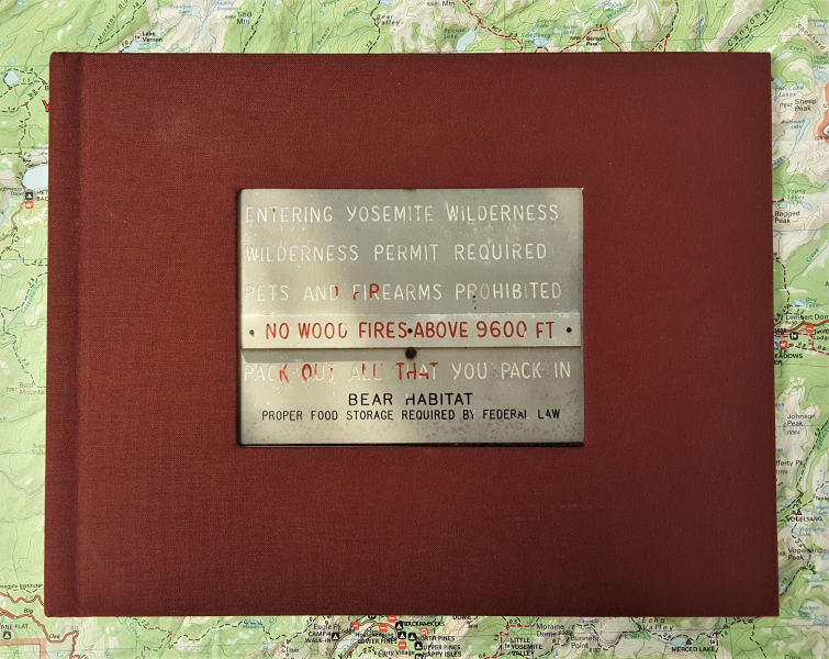 They had stopped by to share Entering Yosemite Wilderness, a book they’d produced about their shared Yosemite experiences. As they began recounting stories, the bustle of the city below faded away, and descriptions of remote trails, scree fields and quiet lakes quickly transported us to the mountains.
Beth and Susan first met by chance nearly 30 years ago, on the slopes of Mount Diablo (about 40 miles east of San Francisco). After a second serendipitous meeting on the same trail three weeks later, they discovered a mutual affinity not just for the outdoors, but specifically for Yosemite. They’ve been together — and adventuring — for more than 26 years.
Beth made her first visit to the park in the late 1950s. She was only 3 or 4 years old, but distinctly remembers driving over Tioga Pass. Since then, she’s visited Yosemite more than 100 times.
Susan’s Yosemite adventures started a few decades later, with a handful of visits in the ’80s. One of her first Yosemite memories is of her inaugural visit to Tuolumne Meadows, where she recalls feeling that the landscape “filled something in my soul.” In the early ‘90s, she celebrated her 50th birthday by climbing Half Dome; now, she and Beth count a dozen Half Dome summits between them.
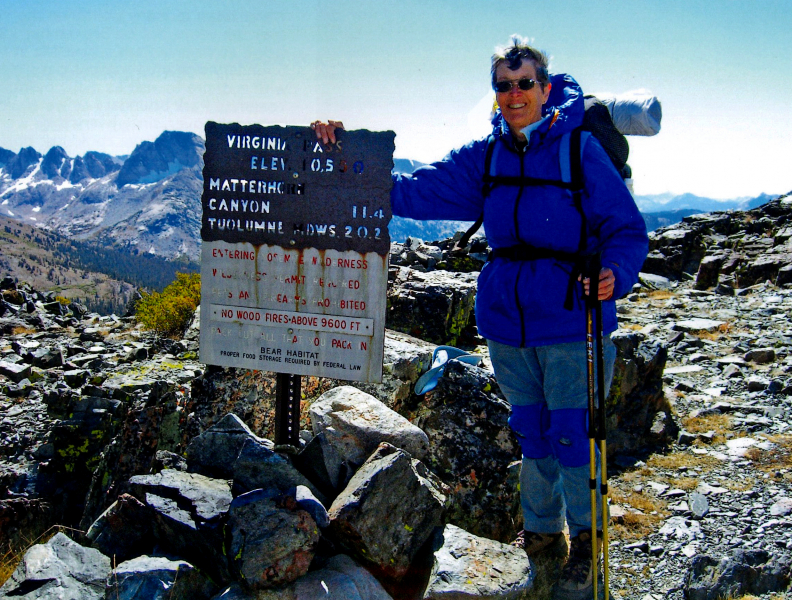
A fateful day at Virginia Pass sparked the idea for Beth and Susan’s multiyear adventure.
Sitting together in the office, we flipped through the book’s glossy pages and stopped at one of the first photos: Susan, standing by an old metal “Entering Yosemite Wilderness” sign at Virginia Pass on September 25, 2006. As the caption explains, they “were surprised and enchanted” to come across the sign in that remote corner of the park. “How long had this sign been there? Why have a sign at a trailless pass?”
In that moment, Beth and Susan made a decision that would guide their adventures for the next several years: They wanted to “bag” every Yosemite boundary sign.
Recognizing the immense scale of their endeavor, they decided to “grandmother in” past trips toward their park boundary tally. “Entering Yosemite Wilderness,” which they finished in 2013, covers more than 20 years of hikes in a series of photos and entertaining stories.
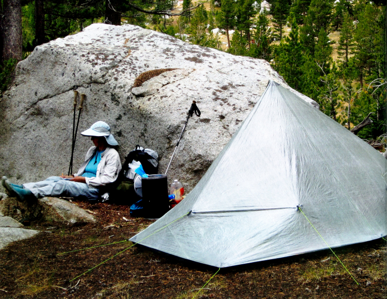
Beth and Susan have learned to limit their pack weight by choosing supplies judiciously — and using an ultralight tent.
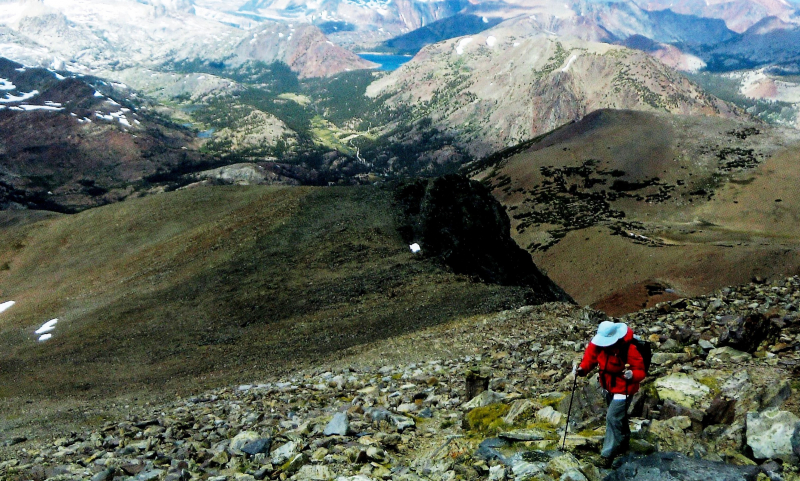
The book traces their travels geographically, moving clockwise from Virginia Pass. Backpacking trips brought them up talus slopes and sharp ridges, over lingering summer snow, through storms and mosquito swarms, and into striking granite bowls. Day hikes ranged from gentle wanders on the park’s low-elevation western edge to a 24-mile trek to Mount Conness. As they passed in and out of Yosemite, they crossed personal boundaries, too, testing their physical and mental strength as they learned to navigate cross-country in remote areas, or to safely climb and descend rocky slopes.
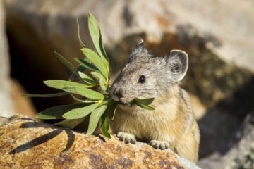
On each excursion, Beth and Susan searched for the signs that mark the Yosemite boundary. Those weren’t always easy to find — some signs had fallen, others were just small markers affixed to trees. At one lakeshore breakfast spot, they couldn’t track down the official line between the Yosemite and Emigrant wildernesses, but decided it was clear in the location’s name: Boundary Lake.
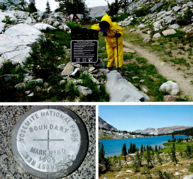
Boundary markers come in a variety of shapes and sizes!
In total, 44 boundary points made the book. We went over some superlatives:
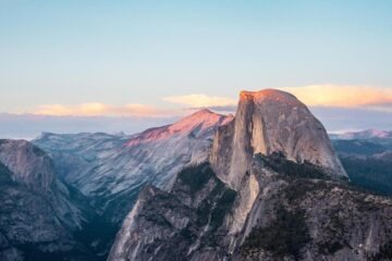
Highest point: Mount Dana (13,057’). Their first ascent, in 1992, taught them a valuable lesson: Going from sea level to 13,000 feet in 48 hours has consequences, including headaches, stumbling and a miserable summit experience. When they returned in 2011, with far more hikes under their belts, they took plenty of time to acclimate, enjoy the wildflowers in Dana Garden and take in the 360-degree views from the top.
Susan climbing Mount Dana, against a backdrop of seemingly endless peaks.
Hardest hike: Shepherd Crest (12,000’). The rocky, trail-free scramble to the top tested their resolve, but a whimsical reward awaited: a summit register tucked away in a colorful lunchbox.
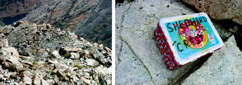
A fun surprise stood out against the rocks on the summit of Shepherd Crest.
Firsts and lasts: Chronologically, their first boundary point was the 1992 Mount Dana summit. Their first “bag” after deciding to pursue this project in 2006 was Summit Lake, which they passed the day after inspiration struck at Virginia Pass.
The last adventure chronicled in the book is a 2012 expedition near Hetch Hetchy. They couldn’t find a sign or marker, but eventually came across a barbed wire fence, and decided to count that as the boundary. A few years after that somewhat anticlimactic ending, they added a 45th point to their list: Tower Peak Pass.
Favorite peak: Mount Conness (12,590’). Beth and Susan were inspired to climb Mount Conness after chatting with a Glen Aulin camp manager who was “somewhat obsessed” with the peak. Now, they’ve reached the top twice – once from the west (1994), and once from the east (2004). They’re deeply attached to the peak, drawn to its thrilling knife-edged ridge and recognizable shape, a touchstone they can spot from different parts of the park.
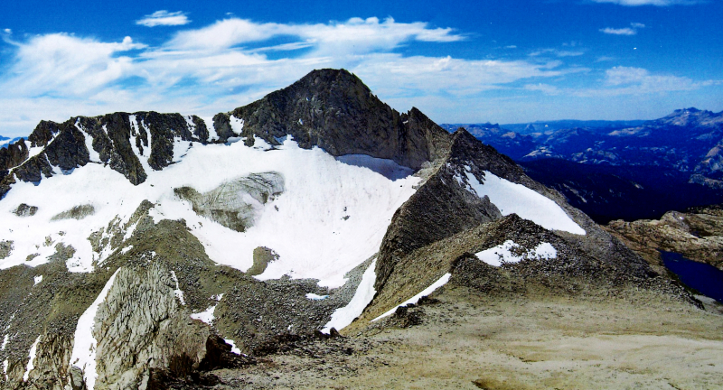
Mount Conness, Beth and Susan’s favorite Yosemite peak, is one of the highest mountains in the park.
Most lost: Between White Mountain and Tuolumne Meadows. Unsure of their location, they ended up in a patch of trees, and serendipitously stepped out onto Tioga Road as the last shuttle was passing by. They flagged the bus down and, per usual, knew the person behind the wheel. As Susan said, “You know you’re retired when you know the names of the shuttle drivers!”
That said, “lost” is a relative term for Beth and Susan. “We’ve never been lost on a macro level,” Beth said, explaining that they always have a sense of where they are in the park. “Once you’ve climbed a peak, your relationship with it has changed forever,” she continued, noting a deep familiarity with the mountains, forged over years and hundreds of miles. Beth and Susan can stand on a summit in Yosemite and name dozens of features they recognize, all of them attached to memories: Hoffmann’s thumb, Mount Lyell, Cathedral Peak— and, of course, Mount Conness.
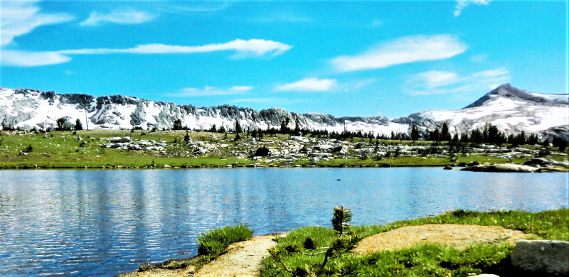
Breathtaking scenery — like this view, looking toward Isberg Pass — is a recurring theme in Beth and Susan’s adventures.
Mountains and lakes dominate the photos in the book, but they don’t tell the whole story. Beth and Susan’s tales weave in the people who helped shape their journey: Shuttle drivers Barbara and Herb, who became familiar faces on journeys to and from high country trails; fellow adventurers who inspired them to hike the John Muir Trail, or whom they inspired with their own impressive feats; and Ron Kauk, their dear friend and the climber behind the nonprofit Sacred Rok.
Their book ends with reflections on their journey. What did they get out of the experience? Beyond the satisfaction of “bagging” more than 40 boundary points, and the sheer fun of spending so much time in the Sierra, they got to connect with the park in a way that few can fathom.
“We developed a sense of Yosemite as a whole,” they write. “We explored peaks and canyons in all corners of the park, and spent endless happy moments identifying old friends in the view.”
The final page leaves the authors (and readers) with a challenge: Keep adventuring. “What will we do next?” Beth and Susan wonder. “Walk every trail in the park?”
Hiking all of Yosemite’s 800 miles of trails would be an astounding feat, but Beth and Susan have already covered plenty of terrain, so who knows? Whether or not they land on another ambitious goal, their “old friends” will always be there, beckoning them — and anyone lucky enough to read about their journey — to enter the Yosemite Wilderness.
Entering Yosemite Wilderness: Where They Went
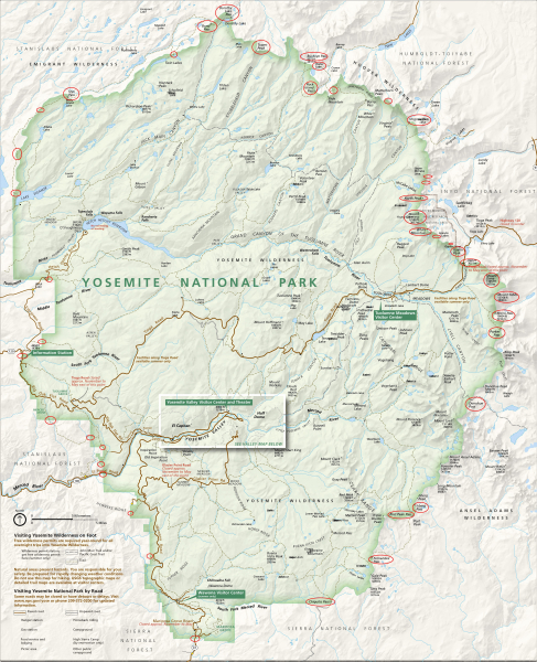
1. Virginia Pass (10,500’ – 2006)2. Summit Lake (10,150’ – 2006)3. Shepherd Crest (12,000’ – 2009)4. Secret Lake Pass (11,250’ – 2003)5. North Peak (12,242’ – 2003 (first attempt), 2006 (summit)6. Mount Conness (12,590’ – 1994 (from west), 2004 (from east)7. White Mountain (12,057’ – 2005)8. False White Mountain (12,002’ – 2003)9. Great Sierra Mine (10,750’ – 2012)10. Gaylor Peak (11,004’ – 1994)11. Tioga Pass – Hwy. 120 (9,945’)12. Mount Dana (13,057’ – 1992 and 2011)13. Mount Gibbs (12,764’ – 1994)14. Mono Pass (10,604’ – 1996)15. Parker Pass (11,100’ – 2006)16. Donohue Pass (11,050’ – 2005)17. Isberg Pass (10,500’ – 2009)18. Post Peak Pass (10,750’ – 2011)19. Fernandez Pass (10,162’ – 2011)20. Chiquito Pass (10,150’ – 2011)21. Hwy. 41 (near Mariposa Grove)22. Alder Creek (2012)23. Yosemite West (2012)24. Hwy. 140 |
25. Foresta Falls (2012)26. Little Nellie Falls (2012)27. Crane Flat (trail to Foresta) (2012)28. Merced Grove (2012)29. Hwy. 12030. Carlon (2012)31. Aspen Valley Road (2012)32. Evergreen Road, near Hetch Hetchy (2012)33. Lake Eleanor (4,657’, 2005)34. Kibbie Ridge (8,094’, 2011)35. Styx Pass (7,650’, 2011)36. Boundary Lake (7,533’, 2011)37. Upper Twin Lake (8,906’, 2012)38. Bond Pass (9,750’, 2010 and 2012)39. Dorothy Lake Pass (9,500’ – 2010 and 2012)40. Buckeye Pass (9,572’ – 2007)41. Peeler Lake (9,489’ – 2007)42. Rock Island Pass (10,150’ – 2007)43. Mule Pass (10,500’ – 2007)44. Horse Creek Pass (10,700’ – 2012)45. Tower Peak Pass (2015, post-book) |
All photos are courtesy of Beth Ogilvie and Susan Straghalis, from their book “Entering Yosemite Wilderness.”